Navigation......................................
01.
Home
02.
General Lead Mining History
03a. Halkyn Mines: History
03b. Halkyn Mines: A few artefact photos
03c.
Halkyn Mines: info downloads
03d.
Halkyn Mines: Don Richardson - electrician
03e. Milwr Tunnel: Recent work
04.
MAP: Veins of Halkyn Mountain
05. Blaen-y-nant vein, Eryrys
06. Westminster vein, Eryrys
07. Fron Fownog Flats, Gwernaffield
08.
Pilkington's vein, Loggerheads
09.
North Henblas Mine, Milwr
10.
Deterioration of the mining record
11. Talargoch Mine
A.
Mines lighting old & new
B. Links
C. Further reading
D. Cris's Shop Window
07. Fron Fownog Flats, Gwernaffield
Click image to enlarge
Cross-section of the oldest and shallowest workings on the Lower Flat. Redrawn from original document Ref: D/HM/273 (courtesy of Flintshire Record Office).
Fron Fownog Flats
An interesting mine where lead was found in 'flats', not veins. Called
by local miners flats or pipes, the ore was deposited in gently dipping
horizontal beds rather than the more common near-vertical veins
so typical of the area. Miners have described the ore as occurring
in natural fissures or tubes in the rock. There are several examples of
similar flat workings, most commonly occurring at the eastern boundary
of the carboniferous limestone, where limestones dips below the
overlying sandstones. “The
pipes were full of sand in which the ore lay as a bed” (Smith
1921). There were two parallel flats at Fron Fownog, one above the
other, lying 25 yards apart.
Although all shafts are now filled, the mine had an incline entrance at
its western end where the flats outcropped along the surface. At a later
period, Downhill Quarry removed the actual entrance. The continuation of
this incline therefore lies somewhere in the floor of the quarry,
although attempts to excavate a way into the incline in the 1980s was
not successful.
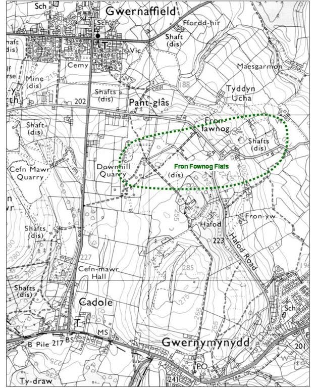
Location of Fron Fownog Flats indicated in green
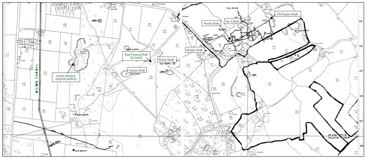
Above: Halkyn District United Mines in 1987 plotted some of the
eastern underground workings of Fron Fownog flats. Other workings are
also shown on this 25" OS sheet.
It is not known when mining was first carried out at Fron Fownog, although it was certainly being worked throughout most of the 19th century. Official output figures were only kept from around 1845, after which the highest recorded output occurred in 1848 when the mine produced 1695 tons. The last production figures are for the year 1880 when 117 tons of lead ore were produced.
The earliest workings were carried out on the lower flat which outcropped at surface around SJ208637. Later mining was carried out by the Great Fron Fownog Company (1869-1875) under their agent Wm. Wasley, and by United Mines (1876-1878). Both companies worked the upper flat which occupied the area to the east where this flat was found at a depth of 160 yards in Engine Shaft. Unlike most workings of the Mold - Rydymyn area, Fron Fownog mine is physically unconnected with any neighbouring workings.
A set of four detailed plans exist (refs D/HM/271-4 Flintshire Record Office) showing the workings to be interesting and more extensive than the survey above suggests. The shallower, older workings on the lower flat occupied a two dimensional area that can be imagined as a table-top, but with a slope to the east of about 1 in 4. The western end of the flat was worked from the surface where it once outcropped. Here two inclines were driven in from the surface (see survey above). The mine was worked from nine main shafts and drained by an adit at approximately SJ218642.
Main shafts and approximate depths from west to east: Taylors (or Whim); 150ft Fownog East; 200ft Reeds (westerly of two); 240ft Mostyn’s; 240ft Parry’s; 255ft Reeds (easterly of two); 300ft No 3; 395ft Inclined; 400ft Engine; 480ft
Modern exploration The workings have not been entered since closure around 1880. All main shafts appear to have been filled. The two inclines provide the best option to gain entry to this mine, although some work with a Hymac excavator was done here in the 1980s, without success. The inclines are shown on a mine section only (not plan), hence pin-pointing the location of the entrances is difficult. This is complicated further as a surface quarry (Downhill Quarry) now occupies the area where the incline entrances would have been. If all loose material were completely excavated from the quarry, it is likely that the ‘South Inclined Plane’ would be visible at a depth of about 40 feet below the original surface level (i.e. in the wall or floor of the quarry). The adit at SJ218642 was driven south-west to drain the workings. It passed through Engine Shaft and ended at Inclined Shaft where water rose from flooded workings below. Therefore, even if the blocked entrance could be excavated, a dry connection to the shallower workings would be unlikely. The shallower workings to the south-west may possibility be dry as plans show a ‘swallow’ near Reed’s (west) Shaft.
______________________________________________________________________________________
Clwyd Powys Archaeological Trust describe the workings as: CPAT Historic Environment Record as number 103219, grid reference SJ21556385
Workings An area of at least five recognisable old shafts and associated spoil, one a possible horse whim at SJ21396379, are located in the area of Fron-hyfryd Farm. There is certain real evidence of the engine shaft which apparently worked the mine at SJ21506380. A second area of five large shafts and associated mounds are located at SJ21006370 to the east of Downhill Quarry and south of Pant-glas. Shafts remain at SJ20906390, SJ21056375 (possibly Taylor's Shaft), SJ21056365, SJ21256360 and SJ21306370. An incline shaft ran from SJ20806375
Power Barton (1989) and Bayles (1969) record an 85" engine being ordered in November 1870 for the Great Fron Fawnog Mine from the Perran Foundry. A 60" engine was built for the site by Hawarden foundry together with a 14" twin cylinder winder and capstan, and an 18" example. A possible horse whim circle is visible at SJ21396379.
|


